My photo
read the blog(s) and find out.

Sunday, July 27, 2008

Day 9, Part 3

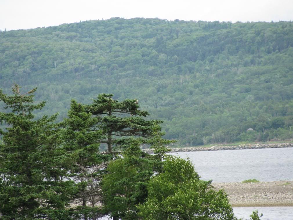
Back on the Cabot Trail I road east until Cape North. I stopped for Gas and chatted with the woman running the place. I told her about Stupa and she wasn't surprised. She told me that had i kept going a little bit further, I would have seen their monestary, which you can visit unless it's the dinner hour. At that time, it's complete silence and visitors aren't allowed. I'm kicking myself for not going all the way to the end of the road, but what can you do. Maybe I'll go next year. Going north I pulled over to take a picture of this Estuary. I liked it.


I headed north and the GPS said that a historic site was up here called Cabot's Landing. People think that John Cabot discovered the continent of America at this location in 1497. The Cabot Dilemma No one can prove where he landed it seems.


It's still neat to think that somewhere around where I was Cabot found the continent. (personally I think he found Newfoundland)


There was a nice beach here, but I didn't feel like going swimming at this time. heh. Maybe I'm afraid a big sea turtle will think my toes are lunch.

I headed north and wanted to get to Meat Cove as I had heard through work that this was a remote spot and the road was bad going up there, so I knew I had to see it for myself. The road was rough but great at the same time (i think about 13 km of gravel/dirt) and almost ran over a suicidal chipmunk, but I missed him and he ran back to the trees. stupid chipmunk. Stopped a few places on that road and enjoyed the view. You do get the sense of how remote this area is. It's one road and there's no other way out but the way you come in. here's a view overlooking the campsite at Meat Cove from the road. From the trails off of Meat Cove people can whale watch from the shore as they swim by. I didn't do that myself... need to get in shape if I'm going to be doing any hiking!

Left Meat Cove and as usual, stopped to take pictures along the way. Some really nice scenery in this area. I stopped at a little fry hut called "The Hut" for a dog and fries and headed back south, hoping to find a room somewhere before dark.

The road south was nice, stopped a bunch of places along the way and made my way to the 105, which i followed north to Sydney. Got a room and went back riding in the area. some nice little communities there and had a nice sunset near Point Edward.

Day 9, Part 2

STUPA


Coming around a bend, I see this very large monument/statue of Stupa. I was quite stunned to say the least as there's pretty much nothing but a dirt road and trees on both sides, and to one side on a little clearing, is this very bright white buddhist monument. it seemed a little out of place at first, but then it didn't. it was peaceful reading the slogans and saying which were inscribed in stone around it.

I liked these slogans, when applied to riding.
well, the last one at least. Don't try to be the fastest. goes with motorcycling and as the saying goes there, it's "ride your own ride"I read the stones and sat around for a bit and relaxed. The more I thought about it the more it made sense to put this were it was. nothing around to distract you. I'm not one for meditation and religion and all, but if I were, this would be a perfect spot for it.

I got back on the bike and went about 100 yards further down the road which dwindled down to two ruts and was getting really narrow. I figured it was a driveway for a private residence, so i turned around and headed back to the Cabot trail.

There was a little store on the Cabot trail to get some smokes and some food and I picked up a pepperoni stick that was packaged with a cheese stick. It was the oddest thing ever and a good little snack on the side of the road. wish I could find that around here, but I guess I could always buy pepperoni and just cut some cheese. I also bought a pack of 'Bailey's' which have an biodegradable filter. neat to see that, but the smokes sucked.

-to be continued-

Day 9, July 27th

Slept poorly in the tent. Back isn't used to hard gravel ground. I used one of those little blue pads you can buy, but it's crap. To add to that, i had some kind of forest rat rummaging through my luggage that was under a tarp outside the tent. Don't think I had any food in there. At first i thought it may be a bear (there are some in the park I was camping in) but i got up and went out to look. I scared away the little chipmunk. damn him. The shower at the park was one of the best I've had all trip. The water was hot and there was a lot of pressure. Packed up and checked out of the camping spot.

note to self: get inflatable mattress.

Today I was going to do the Cabot Trail in the Cape Breton Highlands National park. I was all psyched since people were telling me it was the best thing since sliced bread.

The western shore of Cape Breton through the park is quite a nice ride with many places to pull over and look at the scenery of the coast. Once you turn more inland the road is still nice, but looking at trees can get a little boring.

I was looking at the GPS and I could see a road splitting off the Cabot Trail at Pleasant Bay, going north to Red River. I didn't know what was there as I didn't read any guides or touristic information on the area. I just felt like exploring, and figured if there's a road, there's usually something interesting at the end of those roads. I decided to turn off Cabot Trail onto that dirt road in Pleasant Bay. It's a gravel/dirt road and anyone that saw me waved to me. Nice people in these parts. Slowly continued on this dirt road and then about 8 km later, a buddhist statue!!

Today was to be a very long day, leaving the campsite at around 9am and getting a room at a motel that night at about 9pm, only having gone about 400km. but many pictures were taken and and I had a pretty good day in general.
-continued in next post-

Saturday, July 26, 2008

Day 8, July 26th

Woke up and got my morning coffee at a Timmies and decided to up the coast and see what's up there. I followed the Sunshine trail i believe it was called up to Cape George. it was a nice ride, the roads were good and the views were really nice. got up to the Cape George lighthouse, and snapped a few pics there. It was a really nice site, high above everything

I really liked Cape George... it was very peaceful. I keep saying that, maybe i was just looking for some peace and quiet and solitude. Guess i found it in little bits.


Did the loop of the sunshine trail and it comes back to Antigonish. I figured that since Antigonish was a university town, there would be an internet cafe somewhere around there. Bingo. Found one. used it for about 45 mins and it cost me $2.40 i thought he was kidding me. I've used an internet cafe at one place in montreal and it cost me like $20 for an hour. heh.

Off to Cape Breton!

Right before i hit the Canso Causeway canal, I stopped for fuel and food at the Irving truck stop there. Good food. While chatting with the waitress about my camera and she loved the 10x zoom on it, she said i could probably take a picture of the bald eagle from where I was sitting. it's nest was far away in a tree, and could barely make it out. when I finished eating I went out and took a picture as close as i could, which isn't much, but thankfully high-rez and zoom works well :) here's the original picture... i reduced it/cropped it to get this. Not the best picture but at least I got a bit of it.
Hopped on the bike, went across the causeway and made a snap decision as to go clockwise or counter-clockwise around Cape Breton. Since I was going clockwise around the maritimes, I decided to keep with the theme and took a left. I didn't go to the Cabot Trail as i wanted to stick next to the coast. I landed in Port Hood and little did I know it's Al MacInnis' home town. woot. cute little town. little is the key word here. I kept going north and eventually got to Cheticamp. no vacancy on any motels to be found, so since I had some camping gear, i decided to camp out for the night (it wasn't supposed to rain that night) and headed for the park for a camping spot.

I went back to a store I saw on the way to the park and they advertised camping supplies. woot. Walked in and got some fire starter, an axe, hot dogs, beans, milk, bread and water.

Like J.G. said, what you forget or don't bring, you can buy... he was right got back to the campsite, loaded up the wood I bought there (you have to bring in or buy there since it's a protected park and you can't even burn dead wood, branches or twigs)
had myself a fire, cooked my food and entertained myself with my lamp

Friday, July 25, 2008

Day 7, July 25th

Happy birthday to me.

heh. I think I wasn't fully awake when I took this picture.

should make a list of things to do on my birthday.
  • ride down a long red dirt road
  • get bike stuck on a beach
  • take a ride on a big ferry
  • eat an ice cream cone
  • Ride it like it's stolen
  • watch the sun set

Sound like fun, don't it?

decided today that i would follow the old biker mantra and never double back on my own steps. so instead of taking the same road i did the day before to get from the east coast of PEI to Charlottetown, i decided to take back roads to get to Montague. The dirt roads are actually pretty smooth and fun to ride, but i wouldn't want to do it in the rain, that's for sure.

From Montague I took the 17 around to St. Mary's bay where they had a really really long beach. pretty nifty as the road to the lighthouse had water on both sides. still didn't feel like swimming though, so i got back on and wanted to get to the ferry before it got to late in the day. On the 17 there was a sign for another beach, so i turned in that direction. I believe I found Poverty Beach. I drove down the dirt road until it turned into sand, and kept going figuring that others came before me , so I shouldn't have a problem. BZZT. wrong answer. The bike can go over sand and deep sand with only a few snags, the problem I didn't think about is how I was going to turn it around without getting it REALLY stuck.
The picture with the 2 sandy ruts is where i came from and had to go back out of. It took me about 20-25 mins, and about a 40 point turn rocking the beast with all the gear on it, and i managed to get it turned around. heh. At least now I know what not to do.

Got back on and toured around a bit more and ended up at Wood Islands ferry crossing. I bought my one way ticket ($38 i think) and since I was on a motorcycle, I got to be first in line on the ferry (after the walking passengers). Got to be first on and they provided straps to tie the bike down, even though they didn't expect any rough waters.

note to self: buy tie down straps!

The straps they provided were slimy, disgusting and stank!! after i took the straps off the smell was still on my bike. nasty stuff. tied it down, went up and enjoyed the 2 hour ride. We had musical interludes on the ferry. One guy played guitar and sang (was pretty good) and when he was done, a guy got his bagpipes out and started busking on the top deck. It helped pass the time. I had my GPS on me, so i know the ferry was moving 21km/hr at most. that's like what... 10 nautical miles/hr?

Gave me time to eat an ice cream cone :)

Hit Nova Scotia and I was one of the first off which was nice and headed into new glasgow... not much there, but a nice little town nonetheless. Headed towards Antigonish and was trying to see if i could make it to Cape Breton before sundown. Got a room outside of Antigonish and toured around for a bit before hitting the hay. I got on the big highway between Antigonish and New Glasgow and let 'er rip. was a while since I opened her up :)


Was on Mountain Rd. near New Glasgow and watched the sun set. very relaxing. went back to the motel for some sleep as I could see the storm clouds coming.


Thursday, July 24, 2008

Day 6, July 24th

From New London Bay, I road the Blue Heron Coastal Drive up to highway 2, and drove north on the 2 to the 16 to see the eastern side of the Island.

I went through cavendish, but it seemed more of a tourist trap and a kids type of thing. Where else can you see a replica space shuttle on the side of the road?
Continued on to PEI national park where I took some more pictures of beaches. I kept thinking to myself I have to swim in the ocean at least once on this trip. The day was ok, but I didn't want to dilly-dally around and wanted to get a move on to hopefully get to Charlottetown by sundown. It was a nice beach, but was quite windy and overcast, and I wasn't that hot that i needed to cool down any. There would be other beaches.

Taking some smaller roads I wound up in a small fishing community and drove over a tiny one lane bridge to another side that had a beach and an empty pier. Of course I just had to ride the bike to the end of the pier and take a pic of the bike. It was hard to get there and back due to the really deep sand between the road and the pier, but it was only 40 feet or so of sand so I didn't think I'd have much of a problem. I didn't :)

I rode to the north east point of PEI, to another lighthouse... 3 corners of the island done so far, 1 more to go. While here I could see the ferry from Souris to Iles-de-la-madeleine in the distance and i also saw a band from the 80s. heh.

Made my way out to Souris and could see where the ferry takes off from, and again another monument to those lost at sea.
It's sad to see really. People should just stop eating fish ;)

I left Souris and headed for Georgetown. Didn't know what was there, but it sounded interesting and it looked interesting on the GPS.

Wasn't that interesting, but still nice to ride out there and explore a bit. took a little photo-op for my bike with some boats in the background on the pier.

From there I headed to Charlottetown and got a room for the night in Stratford, which is across the Charlottetown harbour. The room was nice enough and decided to go out and explore the city (town) for the capital of the province, i guess i expected a bit more. It's a nice city, but not huge by any means. Did a bit of night riding before going to bed and avoided quite a few animals then.
A group of 3 porcupines, 3 raccoons, a cat and another porcupine.

When there are that many animals in a short distance, it's time to go to bed and ride during the day.

Wednesday, July 23, 2008

Day 5, July 23rd

I figured if I kept up my fast and furious pace like in the last few days, I would blast through the maritimes and not see anything, so I told myself to slow down, take it more of the sights and enjoy the journey more. I can't really call it a trip as I didn't have a real destination. I now understand what Denis from sudbury told me in Caraquet that some days he only does 200km. It's about the journey and what you see and do along the way.

I looked through the phonebook for an Internet Cafe and they only had 3 for the whole province listed. The phonebook threw me for a loop as both the white and yellow pages were in this tiny little book no thicker than my cell phone. wow.

It was raining when I woke up and they announced rain for the day. I suited up and made sure the luggage was covered up.

I decided to try to take all the coastal routes around PEI, and left summerside going southwest, clockwise around the island. This put me on highway 11. The road conditions were horrible with big potholes, potholes filled with sand and gravel and generally in poor repair. This road is almost dangerous if you are going too fast and catch a sand filled pothole in a corner.
I stopped along the road at one point for a smoke and could see a storm/rain coming my way, and it didn't look too promising

The 11 dumped out onto the 2 and went northwest and got onto the 12. I made my way up the coast to a nice little town of Alberton.

They had a monument on the side of the road so i had to check out what it was about. In 1906, 10 men quickly volunteered to save some mariners from a 60 ton vessel that was being shipwrecked and only the captain of the ship was lost. the monument is to commemorate the bravery of those 10 men.

The more I visited small towns on the coast, the more of these types of monuments I've saw. Many war monuments and mariner monuments. and churches. holy crap there are a lot of churches.
Continuing on the 12, I went north and stopped at a rest stop/beach along the way south of Tignish. This was the First time I went to a beach anywhere and decided to sit and relax and listen to the ocean for a bit. Quite peaceful.

I went to North Cape and took some pictures there. It was worth the ride up to know I went to the most north western part of the island I could. North Cape also has a wind farm and I believe a government windmill test site. neato.
Pictured here is the longest natural rock reef in north america. There's also one of the oldest lighthouses in PEI here (built 1866) and the Black Marsh Trail. You can easily spend a day at this site looking for shells, etc.

I headed south from there and got myself on a dirt road somehow. previous rain and the red PEI soil make for a very very dirty bike. heh. I got on the 14 south and went around and met back up to the 2, but I crossed the 2 and headed towards Lennox island.
I didn't know what was there, but I was curious to see what it was. Once I got there, I realized it was a first nations community. I've never seen so many people wave to me in all my life. The population of the island is about 245, and from what i saw, there is a deep sense of pride in these people. for a small village, it was really something to see. Evidence suggests these people have been here for 10,000 years. wow. I wish I had taken pictures there.

I looped back around PEI then north on the 106 and came upon this sight. the bright white church with a red roof, with this dark onimous cloud over it with nice green grass. breathtaking to see in person.

Wound up in New London Bay, and it was getting late and rode past the New London Bay Motel. Great little place and very motorcycle friendly. The owner is also a rider :) I got myself an apartment for the night. the place was twice the size of my apartment in Ottawa!


Took a little evening ride for food and sights as the roads in PEI are actually very very good (except for the 11) and all the rolling hills makes it very enjoyable. I think i forgot to mention that every road I went down, it seemed that the grass on both sides of the road (not much gravel on the island it seems) was always recently cut, or they were in the middle of cutting it. It's such a neat and tidy island. even the farms are tidy!

Tuesday, July 22, 2008

Day 4, Part 3

Got to the Confederation Bridge and I wanted to take pictures of it, in case I didn't come back this way and took the ferry to NS. I snapped quite a few pics and was in awe at the sheer size and length of the beast. i couldn't see the other end of it really. you'd have to be really far back to get the entire bridge in one picture, that's for sure.
This was from a lookout near the tourist Info building. There was a sign saying people aren't to go on the beach, but since the tourist info building was shut down, and no one was nearby, I went down anyhow. I didn't disturb anything and wasn't doing anything stupid. :)


Aren't I just a rebel without a clue.

Rode across the bridge over to PEI and it started to get dark. wanted to get a room quickly as I didn't want to be running all over PEI trying to find accomodations. I headed to Summerside on a whim and after about an hour or so searching, I finally found a room. I went back out for a little night ride and a snack and ended up at a Tim's again. no smoking on the property was a bit annoying though! That's probably why it was dead and no one was around. Everyone seemed to get drive-through and go by the wharf and drink their coffee there.